Last Saturday, I took a walk with about twenty other people at the Harvey Ott Biological Preserve. This is where the Calhoun County Trailway Alliance wants to put a 10-foot wide paved cycling trail. Tom Funke, Director of Conservation for the Michigan Audubon Society, led the excursion. MAS owns about 20 sanctuaries. Tom is a Western Michigan University grad (Biological Sciences and Environmental Studies) who is well acquainted with the Ott Preserve, having spent his immediate post-graduation years in Battle Creek and having been a board member of Friends of the Ott Preserve. The Friends is a non-profit conservation group formed soon after the 1994 timber cutting in Ott but just now being reactivated after a dormant period following several tranquil years at the Preserve. We entered at a parking lot at the south end on land donated by the Sutarek family as an addition to the preserve after the logging. I was glad to get a chance to walk a part of the proposed trail, though exactly where the trail is supposed to go needs to be made clearer, at least to me. If I’m reading the available material correctly, the trail goes out of its way to invade the Ott Preserve, potentially bringing traffic whose interest is not the Preserve but mileage on the Calhoun County or North Country Trail. If things go on as they have been, the public may not get a full picture of the specifications for the trail until trail advocates and associated government agencies have settled everything among themselves. Some comments by the trail advocates seem to suggest–maybe are meant to suggest–that that point may already have been reached. We read comments like “Both of these entities could pull their funding for the project if the approved route… is changed.” and “If we change the plan or encounter significant delays in implementation, we could lose dollars committed to Calhoun County….” It does seem clear that part of the route in the preserve is projected to follow the existing main esker trail. We reached this trail after traveling over other sections of the existing foot path, which included an unpaved dirt section, a Trek boardwalk, and an iron bridge. I’m uncertain what the plans are for these sections of the path. Are they flat enough, smooth enough, wide enough, and with a strong-enough base to be incorporated in the proposed trail?
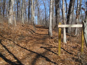
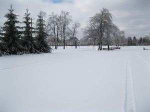
The main esker trail begins not much past the bridge. Currently this foot trail–shown in the first two photos–runs on the side of the esker and is less than five feet wide, or in other words, less than half the width of the proposed paved rail. To the 10-foot paved trail would be added additional 2-foot-wide unpaved right-of-way strips on each side. The resulting 14-foot trail would mean a major remaking of this land. If it actually followed the current trail (which the trail advocates’ literature suggests), a much larger shelf than seen in the photo–three times as wide as shown, maybe more–would have to be cut in the side of the esker. If, instead, the trail followed the top of the esker, a great deal of grading and filling would be needed to produce a flat, level surface for a 14-foot right of way. It seems clear that much more land in the preserve than just a claimed 2 acres (1.7 miles long X 10 feet wide) would be disturbed in the construction. Eskers are interesting land forms. They are formed toward the front of a sheet of glacial ice at a time when the front is just sitting there or wasting away at the end of a glacial advance. Running water carrying rocks, gravel, sand, and silt forms channels through the ice–below it, on top of it, or even as a tunnel within it. The rivers in these narrow. meandering channels deposit the sediments they’re carrying. The result, when the glacier has melted back, are ridges–eskers–of water-sorted, but mostly coarse, material. Aside from damages to the plant cover from construction, the existence and use of such a trail would have continuing harmful effects on the vegetation and wildlife. A broad, paved trail forms a barrier to travel for many small animals, fragmenting their populations. Birds and mammals move away from a trail when people go by, especially noisy people; hence the amount of usable habitat is reduced. Construction and maintenance equipment bring in seeds of invasive plants. Besides these unfortunate biological effects, there are other reasons to be sorry to see the esker whittled away. It’s a specific habitat for organisms, but it’s also a distinctive landform, interesting in itself. An esker is worth protecting. About forty years ago, the city of Portage refurbished Ramona Park on Long Lake in Kalamazoo County. One feature of Ramona Park was the presence of a couple of drumlins. Like eskers, drumlins are glacier-produced hills, but they’re usually small, stream-lined, and symmetrical. Frequently they’re tear-drop-shaped in outline, in which case the pointed ends show the direction the ice sheet was going toward. In fixing up the park, the Portage park department got rid of the drumlins–bull-dozed them flat and used the till to fill in some low spots. I’m not sure whether the Portage politicians and bureaucrats didn’t know that the little hills were drumlins or didn’t care. Possibly they knew very well and flattened them with sincere regret after an environmental assessment and a careful weighing of all economic, environmental, and societal costs and benefits.
Anyway, the drumlins are gone, replaced with playing fields, parking lots, and lawn. I think the citizens of southwest Michigan got skinned.
Preserving landforms–eskers, drumlins, waterfalls, caves, cliffs–is slightly different from preserving ecosystems or flora and fauna, though they go together. But after all, the land is where Homo sapiens has always lived. It’s pretty common for certain unusual landforms to be preserved. Waterfalls, caves, and natural bridges usually get protected, one way or another. There are a few land trusts that specialize in caves, and there could certainly be others that specialize in, say, springs or serpentine soil. But we should recognize that humans have always altered, even damaged, the land they occupy. This includes eskers. Eskers are often associated with swampy or marshy areas, as at Ott, and for as long as humans have lived in the glaciated parts of the world–about 40,000 years for Europe, perhaps 15,000 years in North America–they have probably used eskers, where available, as a dry path. Almost certainly, the local Indians trod the Ott esker, and there’s no reason for us not to do so still. But we ought to tread as lightly as possible, not with bulldozers and asphalt. I expect my ancestors in Europe as well as the Potawatomi here in Michigan walked single file. That’s probably still good enough for us when we’re in a preserve.
Altering our living space is not a uniquely human thing; every organism does it—pigs rooting up spring wildflowers and buffalos enlarging their wallows are just obvious examples. The difference between us and other organisms is that we are, or ought to be, aware of the damage we can do. We can mend our ways rather than wait for destruction and catastrophe to take their toll on us. Instant gratification without considering environmental consequences is behaving like every other member of the animal kingdom. Thought which may lead to prudential restraint is what we do that is human.


Constructing this proposed trail would be tragic.