Category Archives: Plants and Plant Communities

Zombie Seed Production by Garlic Mustard (Alliaria petiolata)

Large garlic mustard 23 April 2011 pulled and placed on forest floor. Photo by Richard Brewer

I need to give the results of the small trial mentioned a month ago, when I put out eight garlic mustard plants (four small and four large) that we had pulled up early in the spring on 23 April at the Audubon Society’s Harris Sanctuary.

I spread them out on the floor of an oak woods on a patch from which I had removed the leaf litter.

Large garlic mustard plant 29 April, six days after pulling and placing on forest floor. Photo by Richard Brewer

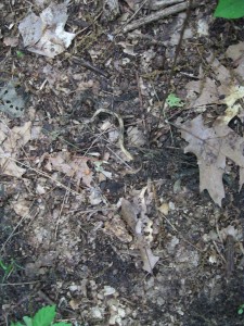
The upper parts of the larger plants remained plump and green for several days and flowers that had not been evident when the plants were pulled appeared on the large plants. (No flowers were seen on the small plants.)  Also, the tops turned upward and the roots turned down.  But soon the plants began to shrivel and darken.  The photo to the left is a view of one of the larger plants on 29 April. By 29 May, the plant bodies, including any flowers, had decomposed, with little structure still evident (see photo below).

Remains of large garlic mustard 29 May 2011 about one month after pulling and placing on forest floor. Photo by Richard Brewer

On the basis of this small trial, it seems unnecessary to remove plants pulled early in the spring.

By early June, most of the second-year plants growing in the woods and on the roadsides have green fruits. It seems possible that large specimens pulled or clipped and tossed on the ground from late spring on might be able to draw enough water and energy from the fleshy leaves and stems to produce viable seeds.

Certainly, many of the invasive species websites tell us that only bagging and hauling the plants away from the control site can head off seed production and dispersal. The evidence is scant, but one study  (K. Solis, 1998, Restoration and Management Notes 16:223-224) seems to show that even plants pulled in the flower bud stage can produce viable seeds.  A serious, well-designed study of adequate sample size would be welcome.

Garlic mustard plants in fruit along an Oshtemo Township roadside. Photo 15 June 2011 by Richard Brewer

Quote 2, Henry David Thoreau on Preserving Land


Each town should have a park, or rather a primitive forest, of five hundred or a thousand acres, where a stick should never be cut for fuel, a common possession forever, for instruction and recreation. We hear of cow-commons and ministerial lots, but we want men-commons and lay lots, inalienable forever….


Button found 14 April 2011 and reused

All Walden Wood might have been preserved for our park forever, with Walden in its midst, and the Easterbrooks Country, an unoccupied area of some four square miles, might have been our huckleberry-field…. As some give to Harvard College or another institution, why might not another give a forest or huckleberry-field to Concord?

–Henry David Thoreau

Thoreau is well known as America’s philosopher-naturalist. Here he gives an early statement of the need to set aside natural land. By the mid-1800s, many people were lamenting the loss of the country’s wild lands, but few took the next step of recommending preservation.  In this passage and also other writings of his later years, Thoreau did.  He not only states that every town (what in the Midwest we call a township) ought to set aside a 500- to 1000-acre preserve, but also notes that the protection should be in perpetuity (“inalienable forever’) and suggests a method–by charitable donation to the town government.

This passage was in his journal for October 15, 1859, but he was also including it, slightly reworked, in his last book, eventually published in 2000 as Wild Fruit.

Early Spring at Mildred Harris Audubon Sanctuary, Kalamazoo

In Oshtemo Township, it’s 64 degrees and sunny this afternoon and the wood frogs in the pond close to the road were clacking loudly.  This morning though, a few miles away at Harris Sanctuary, it was high 30s at the beginning and high 40s at the end.

Audubon sign at Mildred Harris Sanctuary, Kalamazoo. Photo April 2011 by Richard Brewer

I spent the early part of the morning in the beech-maple forest.  It’s still early spring  and none of the spring wild flowers are blooming yet. A few things are up, notably wild leek.  It’s abundant in this sanctuary. The flowers don’t appear till June, long after the leaves are gone.  A few of last year’s flowering stalks are still upright–dry and pale tan–and a few of these still retain a black, shiny round seed.   Never more than one on any I noticed.

I saw quite a few patches of bedstraw, Galium aparine.  This early, they are short thin stems with whorls of miniature leaves.

A fair number of toothwort (Dentaria laciniata) plants were up and had buds.  Maybe they’ll be the first plants to flower here.  In a beech-maple forest in Pavilion Township I visited last weekend, harbinger of spring was in full bloom, but the species doesn’t occur at Harris.

Beech-maple forest at Mildred Harris Sanctuary. The green is wild leek. Photograph April 9, 2011 by Richard Brewer

In 40 minutes or so of walking, I found only one small patch of garlic mustard.  This includes my visiting 20 or so flagged sites where we had found and pulled garlic mustard in past years.  The new patch was not near any of the old ones.  But someone else might have spotted other plants.  The garlic mustard is short, just basal leaves; some other plants might have popped out for someone with good color vision.

I then picked up trash along the two roads that adjoin the sanctuary and walked back to the car through the field half of the sanctuary.  One plant species was in bloom in the field–a low member of the mustard family with small, very small, white flowers.  With its four white petals, it was pretty obviously a mustard, but I couldn’t satisfy myself just what the species was.  Probably in a week or so, when some of the flowers give rise to fruits, it’ll be easier to key out. It seemed to be a weed of the old hayfield–none in the woods.

I wasn’t paying a lot of attention to birds, but turkey gobbling was coming from two directions when I went into the woods.  They quieted down before 9:30 AM.  Red-bellied Woodpeckers and flickers were making noise and there was evidence on some of the dead trees of Pileated work.  As I was walking alongside the field a pair of Wood Ducks flew over making the distinctive upward-slurred “Ooh-eek.”  I’ve read that it’s the female that makes this call, but the two birds are usually together when I hear

Field at Harris Sanctuary, looking north, woods to left. Photograph 9 April 2011 by Richard Brewer

it and I’m not sure that the male never produces it.

And there were Tufted Titmice singing in the woods and Field and Song Sparrow singing at the edges of the field.  And a few more I haven’t listed.

Back Tuesday for our second stewardship work day.

Stewardship Work Days at Aububon’s Harris Preserve Sat 9 April AM and Tues 12 April early PM

Saturday 9 April 2011 is the first Harris Sanctuary (Audubon Society of Kalamazoo) stewardship day, or to be blunt, first work day.  Hours are 9-11 AM.

The second work day is Tuesday, April 12, hours 5:30-7:30 PM.

Anyone who has an interest in the sanctuary and its management is invited to join in the effort on one or both dates.

The other two spring workdays are Saturday April 23, 9-11 AM and Wednesday April 27, 5:30-7:30 PM.

The Mildred Harris Sanctuary is located in the southwest corner of F Ave. and 8th St. in Alamo Township, Kalamazoo County.

What we can accomplish depends on how many people show up.  On this first work day of the year, someone should walk the roads that border the 40-acre property and pick up any debris that has built up over the winter.  When Katy and I visited Thursday morning, there seemed to be no major accumulation.

One change last year in our approach to management included brushhogging along the edge of the forest.  The preserve is roughly 50:50 beech-maple forest (west side) and grassland (old hayfield, on the east side). The one place where garlic mustard is abundant is in the areas along the forest edge occupied by dense growths of raspberries and blackberries or multiflora rose.  Large segments of these all but impenetrable thickets have been mowed down enough that they are not quite impenetrable, hence open for garlic mustard control.

One major task that we will begin Saturday will be attacking the somewhat exposed garlic mustard.  This will be by spraying, daubing with glyphosate, and pulling.  The second and third will be done by the volunteers who show up.

Someone can walk through the beech-maple forest looking for garlic mustard plants, which will mostly be visible as basal clumps of leaves.  In the woods itself only occasional individual or small clusters of plants will be found. Flagging any plants spotted can be followed up on later trips by careful pulling with the pulled plants carried away in bags.

In the brushhogged strip along the edge of the wood, the stubs left over from the larger trees and clubs could be lopped off at ground level to reduce the likelihood of tripping and falling by stewards and other visitors and daubed with glyphosate to discourage resprouting.

Brushhogging was also done in the field.  About one-third of the field was mowed last summer.  We will be interested in how many of the woody invaders resprout as the spring and summer go along.  It’s possible that brushhogging one-third of the field every year, so that the whole area is mowed every three years could keep the shrubs and trees stunted enough that the field area remains effectively a grassland.

One more task that we need to tackle sometime this year is the Mildred Harris Sanctuary sign.  It needs, at a minimum, repainting of the routed letters.  A thorough renovation of the sign, including repainting is another possibility.  A third, if there should be a woodworker with skill at routing, would be a totally new sign.

Katy and I will see you at 8th and F Saturday morning and/or Tuesday early evening. Park around the corner on F Ave. Bring work gloves and any tools you favor.  We’ll have some lopping shears, glyphosate, vinyl disposable gloves, and plastic bags.

Bicycle Trail Through or To the Ott Biological Preserve: A Decision Near

Following is a slightly revised version of a letter that I sent to members of the Calhoun County Board of Commissioners on 29 April 2011.  They will soon (Thursday, 7 April, 7 PM at the County Building, 315 West Green St. in Marshall) be taking an important vote related to whether the Calhoun County Trailways Association will be permitted to run a wide, bituminous bicycle trail through the preserve.

Fringed gentian in fen at Harvey Ott Preserve, Calhoun County. Photo September 1994 by Richard Brewer

I first learned of the Harvey Ott Biological Preserve about 1967 from the study of the preserve’s forests by Tony Catana, then in the Biology Department at Albion College.  I have visited the preserve a good many times since, most frequently in the period after the timber cutting regrettably authorized by an earlier Calhoun County Board of Commissioners. In September 1994, I brought my ecology class from Western Michigan University to study the destruction, and over the next several months, directed a detailed study of the logged site by a graduate student.  In 1994 and 1995 I sat in on some of the meetings of the ad hoc committee that produced a management plan and policies for the preserve.  The plan and policies that were developed weren’t bad.  They would make a good starting place for a stricter and more comprehensive document for the future.

My opinion is that a bicycle trail of any sort, let alone a wide asphalt trail, would be harmful to the native plants, animals, and ecosystems of the site.  Damage would come from construction and would continue during later use of the trail.

I also believe that such an intrusion is contrary to stated aims for the preserve in every stage of its history and under every owner.   This includes ownership by Calhoun County.  To finance purchasing the preserve from Albion College, the County  applied for a federal Land and Water Conservation Fund grant.  Its application stated, “The property was originally purchased by Battle Creek College for a nature-biological study area.  The full intent of Calhoun County is to continue with the preservation….”  The Site Management Plan prepared by the ad hoc committee in 1994-1995 stated, “It is the intent of Calhoun County to maintain the Preserve as an area for passive, non-destructive, recreational, educational, and aesthetic use.” In the Plan, bicycling (and horseback riding, among other things) is specifically prohibited.

In my opinion the plan brought forth by the Trailways Alliance was not well designed.  It’s hard to believe that the group has spent eight years planning and promoting the trail without doing environmental due diligence.  Not only have no studies of the Ott Preserve been done, but it appears that no studies have been done anywhere along the proposed route.  What rare plants or animals or important natural features will be impacted?  But also, what contaminated or otherwise dangerous sites would the projected route take hikers through?

I am a supporter of trails.  Rail-trail conversions around the nation have nearly always been environmentally and socially beneficial.  The same can be said about many other sorts of trails–trails that were thoughtfully routed, carefully designed, and competently executed.  I do not consider trails that invade preserved natural areas to be in this category.  In fact, designing a trail by poaching on  protected public or other conservation lands seems to me a disservice to the citizens of the region– as well as showing a certain lack of initiative.  Optimal trail design would include, among other criteria, a route that eliminates or minimizes damage to preserves, parks, and other sensitive areas.

If the choice is between a hard-surfaced trail running through the preserve and no trail, then no trail is the responsible choice without question.

The only compromise I can see that would be respectful of the values of the preserve and meet the clear duty of Calhoun County as stewards of the preserve would be a trail that stopped outside the preserve, perhaps at a bicycle-parking area, also outside the preserve.  From the bicycle-parking area, a short foot trail to the preserve boundary could allow access to the foot trails of the preserve. Providing a way to get to the Ott Preserve without the use of a car is one good feature of the Trailways plan and probably worthy of retaining–but only if the preserve itself is absolutely protected.

Additional comments:  My impression is that the Calhoun County Board has done a good job of listening.  Perhaps they will adopt some sort of compromise position. But there are an infinite number of possible routes between the northwest parking lot of the Ott Preserve and the stoplight on Michigan Avenue (route mentioned in 12.A in the  Commission agenda for 7 April 2011).  Some of these might be almost totally protective of the Ott and some might be damaging.  It would be desirable that the route to be taken should be nailed down and described in any resolution adopted in the April 7 meeting.  Also spelled out should be the principles to be followed for any trail section where the precise route can’t be currently stated (for example, no alteration of existing land contours).

These requirements are essential considering that any construction is likely to be some little time away, probably several years. Public memories dim.  The trail advocates have fought doggedly for their vision of a 14-foot-wide bicycle path down the middle of the Ott. When construction begins, three or four or five years from now, a strong pull could exist toward dealing with any ambiguities in the statement of route by following the “bicycle-trail-through-the-Ott” game plan familiar to the Trailway Alliance and its allies in county government.

Wide Bike Trail Through the Preserve?: Speak Out to Save the Ott

Take Action on the Proposed Trail Through the Harvey Ott Biological Preserve
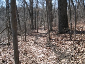
Main esker trail, looking down toward bridge, Harvey Ott Biological Preserve. Photo February 2011 Richard Brewer

The Calhoun County Commissioners will be the ones voting on the trail.  They may give more weight to messages from their constituents; nevertheless, it will be of value to them to know if the threat to the Ott Preserve is a matter of concern to conservationists and nature lovers elsewhere.

Most of the information that follows is from the Say “No” to Pavement: Protect Ott Biological Preserve organization and was supplied by Sophia DiPietro. Comments in italics are mine.  Besides earlier posts at this website, information on the proposed trail through the preserve and its drawbacks are most readily accessible at the Facebook page Say “No” to Pavement: Protect Ott Biological Preserve, especially the Wall and Info sections.

Upcoming Public Meeting–All are invited.

Ott Biological Preserve Proposed “Trailway” Public Forum Thursday, March 17 (St. Patrick’s Day) 5:30pm – 8:30pm

County Commission Chambers (3rd floor County Building)
315 W. Green St.
Marshall, MI

The County Building is near the center of Marshall .  Green is  the main east-west street and the county building is half a block east of Kalamazoo Avenue, the main north south Street.  (As a landmark, Schuler’s Restaurant is in the next block east on Green.)

This is one meeting you won’t want to miss! Don’t like the thought of the proposed “smooth-surfaced highway” through Ott Biological Preserve? This is YOUR time to speak up. There will be at least one presentation by the trailway alliance promoting their trail, and at least one presentation advocating for the protection of Ott. There will be a question/answer period and hopefully full opportunity for local citizens to make their voices heard against this trail proposal.

Come prepared! Make some notes as to why you feel Ott should remain free from development! County Commissioners need to hear from you! A regularly scheduled County Commission meeting follows the forum at 7pm

The Commission NEEDS to hear your opposition to trail development in Ott Biological Preserve. Send POLITE letters either snail-mail or email (scroll to bottom for emails group).

Calhoun County Board of Commissioners

Julie Camp (Republican)(re-elected)
8934 5 Mile Road
East Leroy, MI 49051
Fax: (269) 781-0140
juliecamp5@gmail.com

Terris Todd (Democrat) (re-elected)
135 Irving Park Dr.
Battle Creek, MI 49017
todd4calhoun@yahoo.com

Jim Haadsma (D) (re-elected)
146 South Lincoln Boulevard
Battle Creek, MI 49015
jhaadsma@mccroskeylaw.com

Mark Behnke (R)
474 Country Club Drive
Battle Creek, MI 49015
mbehnke@behnkeinc.com

Steve Frisbie (R)
148 Pheasantwood Trail
Battle Creek, MI 49017
sjfriz@gmail.com

Blaine VanSickle (R)
16828 21 Mile Road
Marshall, MI 49068
No email

Art Kale (R) (Chair)
3101 Country Club Way
P.O. Box 672
Albion, MI 49224
arthurkale@gmail.com

Compiled email contacts for pasting into email
(NOTE: Commissioner VanSickle does not have an email address):
arthurkale@gmail.com, sjfriz@gmail.com, mbehnke@behnkeinc.com, jhaadsma@mccroskeylaw.com, todd4calhoun@yahoo.com, juliecamp5@gmail.com

For Calhoun County residents, to find out who your specific county commissioner is, check out the county website for more info: www.calhouncountymi.org/Departments/BoardOfCommissioners/OverviewBOC.htm

Parks/Road Commissioners who have pursued this trailway jointly with the nonprofit Calhoun County Trailway Alliance (and therefore may not be objective to concerns):

Christopher Vreeland
119 North Grand Street
Marshall, MI 49068
Fax: (269) 781-6101
Email: cbv@vreelandlaw.com

Scott Brown
504 Lincoln
Albion, MI 49224
Fax: (269) 781-6101
Email: sbrown@calhouncrc.net

Hugh Coward
546 Sylvan Drive
Battle Creek, MI 49017
Fax: (269) 781-6101
Email: local340ironworker@sbcglobal.net

Eric Tobin
520 S. Avenue C
Athens, MI 49011
Fax: None
Email: orionet@aol.com

Email Group:
cbv@vreelandlaw.com, orionet@aol.com, local340ironworker@sbcglobal.net, sbrown@calhouncrc.net

Trail through the Ott Preserve: Going out of its way to pave the esker

Main Esker Trail, Ott Preserve. Photo February 2011 by Richard Brewer

Main Esker Trail, Ott Preserve. Photo February 2011 by Richard Brewer

Last Saturday, I took a walk with about twenty other people at the Harvey Ott Biological Preserve. This is where the Calhoun County Trailway Alliance wants to put a 10-foot wide paved cycling trail. Tom Funke, Director of Conservation for the Michigan Audubon Society, led the excursion. MAS owns about 20 sanctuaries. Tom is a Western Michigan University grad (Biological Sciences and Environmental Studies) who is well acquainted with the Ott Preserve, having spent his immediate post-graduation years in Battle Creek and having been a board member of Friends of the Ott Preserve. The Friends is a non-profit conservation group formed soon after the 1994 timber cutting in Ott but just now being reactivated after a dormant period following several tranquil years at the Preserve. We entered at a parking lot at the south end on land donated  by the Sutarek family as an addition to the preserve after the logging. I was glad to get a chance to walk a part of the proposed trail, though exactly where the trail is  supposed to go needs to be made clearer, at least to me. If I’m reading the available material correctly, the trail goes out of its way to invade the Ott Preserve, potentially bringing traffic whose interest is not the Preserve but mileage on the Calhoun County or North Country Trail. If things go on as they have been, the public may not get a full picture of the specifications for the trail until trail advocates and associated government agencies have settled everything among themselves.  Some comments by the trail advocates seem to suggest–maybe are meant to suggest–that that point may already have been reached.  We read comments like “Both of these entities could pull their funding for the project if the approved route… is changed.” and “If we change the plan or encounter significant delays in implementation, we could lose dollars committed to Calhoun County….” It does seem clear that part of the route in the preserve is projected to follow the existing main esker trail.  We reached this trail after traveling over other sections of the existing foot path, which included an unpaved dirt section, a Trek boardwalk, and an iron bridge.  I’m uncertain what the plans are for these sections of the path.  Are they flat enough, smooth enough, wide enough, and with a strong-enough base to be incorporated in the proposed trail?

Width of the Main Esker Trail, Ott Preserve. Photo February 2011 by Richard Brewer

The main esker trail begins not much past the bridge.  Currently this foot trail–shown in the first two photos–runs on the side of the esker and is less than five feet wide, or in other words, less than half the width of the proposed paved rail.  To the 10-foot paved trail would be added additional 2-foot-wide unpaved right-of-way strips on each side. The resulting 14-foot trail would mean a major remaking of this land. If it actually followed the current trail (which the trail advocates’ literature suggests), a much larger shelf than seen in the photo–three times as wide as shown, maybe more–would have to be cut in the side of the esker.  If, instead, the trail followed the top of the esker, a great deal of grading and filling would be needed to produce a flat, level surface for a 14-foot right of way. It seems clear that much more land in the preserve than just a claimed 2 acres (1.7 miles long X 10 feet wide) would be disturbed in the construction. Eskers are interesting land forms. They are formed toward the front of a sheet of glacial ice at a time when the front is just sitting there or wasting away at the end of a glacial advance.  Running water carrying rocks, gravel, sand, and silt forms channels through the ice–below it, on top of it, or even as a tunnel within it.  The rivers in these narrow. meandering channels deposit the sediments they’re carrying. The result, when the glacier has melted back, are ridges–eskers–of water-sorted, but mostly coarse, material. Aside from damages to the plant cover from construction, the existence and use of such a trail would have continuing harmful effects on the vegetation and wildlife. A broad, paved trail forms a barrier to travel for many small animals, fragmenting their populations. Birds and mammals move away from a trail when people go by, especially noisy people; hence the amount of usable habitat is reduced. Construction and maintenance equipment bring in seeds of invasive plants. Besides these unfortunate biological effects, there are other reasons to be sorry to see the esker whittled away.  It’s a specific habitat for organisms, but it’s also a distinctive landform, interesting in itself. An esker is worth protecting. About forty years ago, the city of Portage refurbished Ramona Park on Long Lake in Kalamazoo County.  One feature of Ramona Park was the presence of a couple of drumlins.  Like eskers, drumlins are glacier-produced hills, but they’re usually small, stream-lined, and symmetrical.  Frequently they’re tear-drop-shaped in outline, in which case the pointed ends show the direction the ice sheet was going toward. In fixing up the park, the Portage park department got rid of the drumlins–bull-dozed them flat and used the till to fill in some low spots.  I’m not sure whether the Portage politicians and bureaucrats didn’t know that the little hills were drumlins or didn’t care.  Possibly they knew very well and flattened them with sincere regret after an environmental assessment and a careful weighing of all economic, environmental, and societal costs and benefits.

An Absence of Drumlins, Ramona Park, Portage. Photo February 2011 by Richard Brewer

Anyway, the drumlins are gone, replaced with playing fields, parking lots, and lawn. I think the citizens of southwest Michigan got skinned.

Preserving landforms–eskers, drumlins, waterfalls, caves, cliffs–is slightly different from preserving ecosystems or flora and fauna, though they go together.  But after all, the land is where Homo sapiens has always lived.  It’s pretty common for certain unusual landforms to be preserved. Waterfalls, caves, and natural bridges usually get protected, one way or another.  There are a few land trusts that specialize in caves, and there could certainly be others that specialize in, say, springs or serpentine soil. But we should recognize that humans have always altered, even damaged, the land they occupy. This includes eskers. Eskers are often associated with swampy or marshy areas, as at Ott, and for as long as humans have lived in the glaciated parts of the world–about 40,000 years for Europe, perhaps 15,000 years in North America–they have probably used eskers, where available, as a dry path.  Almost certainly, the local Indians trod the Ott esker, and there’s no reason for us not to do so still.  But we ought to tread as lightly as possible, not with bulldozers and asphalt.  I expect my ancestors in Europe as well as the Potawatomi here in Michigan walked single file.  That’s probably still good enough for us when we’re in a preserve.

Beaver Dam, Ott Preserve. Photo February 2011 by Richard Brewer

Altering our living space is not a uniquely human thing; every organism does it—pigs rooting up spring wildflowers and buffalos enlarging their wallows are just obvious examples.  The difference between us and other organisms is that we are, or ought to be, aware of the damage we can do.  We can mend our ways rather than wait for destruction and catastrophe to take their toll on us.  Instant gratification without considering environmental consequences is behaving like every other member of the animal kingdom.  Thought which may lead to prudential restraint is what we do that is human.

The Ott Preserve and Attacks on Perpetuity

Slash in Ott Preserve after timber cut in 1993-4. Photo March 1994 by Richard Brewer

Preserved natural areas are vulnerable.  I don’t mean they’re delicate.  It’s true that some will need a particular kind of management, such as prescribed fire, and some may not tolerate a lot of human traffic, but good-sized natural areas–a few hundred acres–are often fairly robust.  They’re vulnerable not because they’re fragile, but because there are always certain people who look at preserved land and think it’s not utilized. It’s just empty land, a land bank waiting for their higher and better, destructive use.

The vulnerability is complete when the appetite for a quick, cheap, and easy fix is joined with one more factor:  The organization charged with defense of the conserved land is not up to the job.

We have seen this vulnerability several times in southwest Michigan.  One recent case is the Colony Farm Orchard at Western Michigan University, described in a number of earlier posts at this website.  Land bought with tax-payer dollars was given to WMU by the state with the restriction that it be kept as open space for public use.  But a little more than 30 years later, in 2009, WMU persuaded the Michigan legislature and governor to strip the restriction from the Orchard.  The land is currently open to any kind of development.  Though WMU claimed expansion of their BTR park–to create jobs–as their justification, no such restriction remained in the bill signed by then-governor Jennifer Granholm.

Another example is Jean Klock Park on the Lake Michigan shore at Benton Harbor. It’s a particularly sad case. In 1917, John Nellis Klock and his wife Carrie gave the city 90 acres of coastal marsh and sand dunes, including nearly 3000 feet of lake frontage and beach. It was, as far as I can determine, the first Lake Michigan natural land protected for public use.

Given as a memorial to a daughter who died young, the land was meant to be for the benefit of the people of Benton Harbor but especially for the children.  The city proved a good steward for nearly 70 years. Then, in 1986, the city tried to add a large part of the park to its Downtown Development Authority.  This threat was rebuffed, but another surfaced in 2003 in the form of a proposed luxury housing development.  Although this specific proposal also failed, the settlement reached set the stage for a successful attack within two years in the form of the Harbor Shores development which includes a Jack Nicklaus Signature golf course that has subsumed a large area of the park’s best dunes.

The machinations that resulted in the degradation of Jean Klock Park are probably not yet totally revealed, but even so it is difficult to summarize the operation in a few paragraphs. Several people and agencies that might be seen as having protection of the park and its natural features as part of their job or mission, instead acted to undo the protection.  Among them were the Benton Harbor city commission, Governor Jennifer Granholm (again), U.S. Representative Fred Upton, Michigan’s Natural Resources Trust Fund board, and the U.S. Park Service.  There were, of course, also some conservation heroes fighting the development.

Loss of areas that we have every reason to think of as protected in perpetuity is not restricted to Michigan; attacks are regrettably widespread.  A current example is the pristine Izembek National Wildlife Refuge at the end of the Alaska Peninsula in southeastern Alaska.  The U.S. Congress provided pork-barrel funding to build a 9-mile road between King Cove and Cold Bay, two villages with a combined population of fewer than 900 people.  The road would run through designated wilderness including wetlands that are sites for feeding, nesting, or molting of black brant and Steller’s eider, among other arctic tundra species.   Construction is awaiting an environmental impact statement.

The current attempt to put a wide, paved trail through the best parts of the Harvey Ott Preserve in Battle Creek, Michigan, may not be as globally important as a road in a 400,000+ acre refuge containing wetlands of international importance. But otherwise the situation is fairly similar.

The Ott situation is especially unhappy because Ott has been through this before, about 15 years ago. The Calhoun County Commission sold about 300 trees, mostly large oaks, out of the preserve.  The catastrophe was not as complete as it could have been, because as the result of heavy citizen opposition, the commission canceled a second clear-cut that would have removed the rest of the upland forest in the preserve.

The 1993-1994 Ott timber sale had no redeeming features.  It happened mostly because the Calhoun County Parks Department was broke. On the other hand, a trail for hiking and biking can be a good thing.  (Trails and trail conservancies are given a thorough discussion in chapter 13 of Conservancy: The Land Trust Movement in America.) Certainly the existing foot paths in Ott are, to a point, good things.

One justification I’ve heard for running a trail through Ott is as a connector for the North Country Trail. If a connector is needed, it’s unlikely that a satisfactory route would need to invade the Ott Preserve.  I suspect that Ott has been chosen mostly because those pushing the trail see Ott as being unused, empty, not utilized.

I suspect they also see it as free land.

If the best route–avoiding the Ott Preserve except perhaps for a small spur–would involve private land, private land can be acquired by purchase or the right to use the land as a trail can be acquired as an easement.

Sometimes the right thing to do is a little harder than the expedient one.

It’s possible that a new trail for Calhoun County could be a good thing.  A new trail through the Ott Preserve wouldn’t be.  Ott is utilized.  It’s a preserve.

New Attack on the Harvey N. Ott Preserve, Battle Creek, MI

Shrubby cinquefoil, a characteristic fen species. Photo at Vanderbilt Fen October 1988. Copyright Richard Brewer

The Ott Preserve at the east edge of Battle Creek was the subject of an attack several years ago.  The 260 acres had been preserved early in the 20th century through joint efforts of local naturalists and John Harvey Kellogg.  In 1977, Calhoun County bought the preserve using money from the federal Land and Water Conservation Fund.  Fifteen years later, the 1993 County government, ignorant of what the Ott Preserve was about, agreed to sell 305 large trees, mostly oaks from a southern upland section of the preserve.  Battle Creek citizens and conservationists throughout the state protested and the County Commission backed off from a second cut that would have logged the rest  of the preserve.  There is more about the events of 1993 in Chapter 4 of Conservancy: The Land Trust Movement in America.

Serious damage had been done, but the oak forests of the upland ridges (eskers in geological terms) were saved and the wetlands that include the unusual type of vegetation referred to as fen were not seriously damaged.  Now another 15 years has gone by and a new threat has shown itself.  A group has proposed running a wide, paved trail through the preserve.  Part of the justification appears to be to provide a link with the North Country trail.  Pedestrian trails already exist within the Ott Preserve.  Much is still unclear about the current proposal including justification, alternatives, funding for construction, ability to pay for maintenance in the long term, immediate and continuing impact, and acceptability to the citizens of the county and the region.

The following comments on this current threat to the Ott Preserve were prepared by Sophia DiPietro, an advocate for the preserve and member of the Protect Ott Coalition. They were published in slightly different form in the Battle Creek Inquirer Sunday 6 February 2011 with the heading “Ott is natural gem worth preserving.” The Enquirer website includes several useful comments by readers in addition to the article.


Don’t Allow Degradation of the Harvey N. Ott Preserve

By Sophia DiPietro
The nonprofit Calhoun County Trailway Alliance has proposed a nearly $2 million, 14-foot-wide “smooth-surfaced” trail-to-nowhere through the heart of the 100-year-old Ott Biological Preserve, and throughout Calhoun County. The Trailway Alliance says their aim is to “enhance the quality of life and environment for present and future generations.” As an outdoor enthusiast and healthy lifestyle advocate, I am in favor of outdoor recreation; but at the expense of damaging the natural features of Calhoun County’s only preserve? No way!

Ott Biological Preserve is the most biologically diverse and pristine natural area that Calhoun County has. It is a living piece of Michigan’s geologic history. Ott’s unique 10,000 year-old glacially-formed eskers were once the streambeds of ancient rivers. They wind nearly one mile throughout the Preserve. Unlike the existing trail that follows these eskers, the “hard” engineering required to level out inclines, and to cut and dig a “smooth” or paved ten foot-wide trail (with two feet of clearing on each side,) would compromise the esker. In the blink of an eye our rich geologic history will be replaced with the everlasting footprint of heavy machinery. Downslope lies a globally rare prairie fen wetland habitat (fewer than 2000 acres occur in Michigan,) and three spring-fed kettle lakes– former sites of large ice block melts. These sites could receive inputs of sediment via erosion from construction disturbance and from pavement runoff. These vital headwater ecosystems are habitat to state and federally listed threatened plants and animals. They provide us with floodwater control and groundwater supply filtration that enhances our water quality. Ott provides breeding grounds, shelter, and food to mammals, reptiles, amphibians and birds.  Some may not survive, while adaptable ones may become “nuisances” in adjacent neighborhoods.

Ott’s trails are currently used for hiking, jogging, nature photography, birdwatching, snowshoeing, cross-country skiing, quiet reflection and educational studies. Since the first 105 acres were purchased in 1911, the land has been used as an outdoor classroom, especially for advanced college research. The notion that Ott is not used enough is false, and a “preserve” is no place for 10-speed bicycles, skateboards and rollerblades. In fact, any asphalt, gravel, or other “smooth” development of the trails will eliminate cross-country skiing, snow-shoeing and winter hiking in the Preserve, since non-dirt surfaces are not appropriate for these sports. The proposed smooth impermeable surfaces would retain water in puddles, refreeze into ice and create a slip-and-fall danger. This would effectively take the Preserve out of use for the cold months, when many people are even more active in Ott.

Luckily, an alternative route through Ott exists that is more economical, more handicap accessible, and scenic but with fewer negative impacts. Providing an independently conducted environmental evaluation would give this route a green light, the trail would follow an already-cleared Consumers Energy power-line right-of-way along the west boundary of the Preserve, right to East Michigan Avenue. That exit point places you a mere 50 feet from where the Alliance proposes that their trail meet back up with the same exact power lines, right across the street in Kimball Pines! It could incorporate the placement of a currently un-used historic bridge, to cross over a tributary to the Kalamazoo River. The diversity of “edge-loving” species of birds and mammals that inhabit areas between forest and open habitats makes this alternative route rich in wildlife-viewing opportunities. I have bird-watched this route many times, to my heart’s content.

The development of the preserve as currently proposed would have complex and permanent environmental impacts.  Much more is involved than just “how wide” the proposed trail development is, or “what surface” is used. Transforming this peaceful nature preserve into an urban park would make Ott into what every other urban park is: paved, loud and with limited nature experience. And let’s face it, in a county that is recovering from one of the worst oil spills in its history, does it really make sense to develop and destroy the one last remaining public wilderness area we have?

The 100-year history of the Ott Biological Preserve rests in the hands of the Calhoun County Commissioners. Make your voice heard at Change.org. But also contact Calhoun County Commissioners directly and attend Commission meetings. To stay informed, join our page at Facebook.    Spread the word.

Our Little House in an Unpredictable Habitat

When I taught ecology to biology majors and minors I would occasionally include a question on the final exam something like this:  Describe two ways in which the study of ecology could save your life.

I was happy to accept answers at any level of the environment from “If I don’t build my house in chaparral I won’t get burnt up in the next chaparral fire.” to “I’ll cut down on energy usage, hence CO2 emissions, and I and the rest of us won’t get drowned when we’re living in Miami, Charleston, or Wilmington and the sea level rises.”

Some students got it, but a few didn’t.  For the latter, perhaps ecology was simply a required course, as remote from real life as a class in theatrical costumes of the 17th century.

Just out is an interesting article by two who get it, Jim Armstrong, a poet, and Kim Chapman, an old friend and former student.  Both got a lot of their schooling in Kalamazoo.  The article is called What Laura Saw: Making a Little Home on the Extreme Great Plains. The article is about the Little House series by Laura Ingalls Wilder but puts it in an ecological context.  Ecology turns out to set the social and economic contexts of the Ingalls’ lives also.

The article appears in the recently published Proceedings of the 21st North American Prairie Conference. The conference was at Winona State University in Minnesota in August 2008.

Western Michigan University was host in 1982 to the Eighth Prairie Conference. Kim Chapman, then a graduate student, served as field trip coordinator, poetry contest chairman, and co-designer of the logo.  He was also finishing up his master’s thesis.

What Laura saw around her little house, in Armstrong and Chapman’s words, was “a highly evolved environment, where several thousand years of drought, fire, hail, harsh winters, and intense grazing by ungulates and locusts shaped a responsiveness in plant and animal life that enabled the whole of the environment to persist even as individuals and species disappeared or shifted in abundance and location. That environment was beautiful and hostile by turns and Laura described this in memorable detail.”

The bison and the grasshoppers (the Rocky Mountain locust) were members of this ecosystem.  The locust is now extinct and the bison no longer around as a free-roaming species.  Still extant because they don’t infringe much on human property rights or economics are most of the bird species whose life histories fit them for flourishing in the years of good rainfall and good growth and pretty much moving out in the droughts.  The Yellow-headed Blackbird is an example that I talked about a few months ago.

“The argument threaded through all the books,” Armstrong and Chapman point out, “is that an independent-minded family, pulling together and with a little help from neighbors, could make a living on the Great Plains by their enterprise and hard labor.  As the books progress, however, the reader understands that Pa [Charles P. Ingalls] was not able to realize that dream for his family.  This tension is what makes the books readable today.”

By 1894, Laura and her husband, Almanzo,  had moved to “the well-watered Missouri Ozarks where they lived for the rest of their lives.”  And where Laura and her daughter, Rose Wilder Lane, worked on the Little House books starting in 1930.

The books promote individualism, hard work, and self-sufficiency.  These are admirable traits, but were not enough in themselves to bring success in the unpredictable habitat of the Great Plains.  Even here in the “well-watered” eastern U.S. and, in fact, in the world as whole, we now live in an environment  characterized by unpredictability–largely brought on by our own actions.  Other virtues, especially an attention to the whole ecosystem, human, biotic, and abiotic, will have to be added if success is to be ours.

Copies of the Proceedings, which have a lot of other prairie articles besides this one, are available in 2 formats: CD, $ 8.00 per copy or hard copy, $29.50 per copy. The combination CD and hard copy are $35.00.  All prices include mailing.  Make your check out and send to Bruno Borsari, Ph.D., Department of Biology, 175 West Mark Street, Winona State University, Winona, MN 55987    Phone (507) 457-2822.