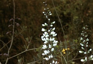
False Wild Indigo growing on land of the former Grand Prairie. Photo copyright Richard Brewer 2009.
This is a short version of a talk I gave at the Oshtemo Historical Society, Kalamazoo County, Michigan, this spring (March 2009) on the original vegetation of the township.
I’m using 1830 as the beginning date. There are good reasons for choosing that year. One of Kalamazoo County’s famous early settlers, Benjamin Drake, arrived with his wife, Maria, on Grand Prairie in 1830. The family settled in the Oshtemo part of the prairie (which extended across the line into Kalamazoo Township). Enoch and Deborah Harris, the county’s first black settlers, arrived about the same time, maybe a little earlier, on Genesee Prairie in the southern part of Oshtemo Township. For the settlers, the tall-grass (mesic) prairies were destinations, like islands in the ocean.
Also,1830 was the year that the General Land Office Survey for Oshtemo Township was conducted. The survey produced data that allows us to form a pretty good idea of what the vegetation was like at the time. The survey and settlement are connected, of course, because the purpose of the survey was to establish the sections,townships, and ranges that provided the framework for the sales of land to the immigrants.
Even though the purpose of the survey was not botanical, it collected information as to species and diameters of trees at section corners and quarter sections, along with their distances from these points, allowing a relatively accurate reconstruction of the vegetation. Using this data and other sorts of information from the original land survey along with topographic information, a map of the vegetation of Kalamazoo County in 1830 was prepared (T. W. Hodler, Richard Brewer, L. G. Brewer, and H. A. Raup. 1981. Pre-settlement vegetation of Kalamazoo County, Michigan [map]. WMU Geography Department, Kalamazoo.
Of course, Oshtemo history doesn’t start at 1830. We know that LaSalle with a band of four men went through southern Michigan in 1680, and it’s likely that his route went through Oshtemo, probably right through Grand Prairie. It was about this time of year, probably the last week of March.
But the Potawatomi were already here, having arrived about 1700 from Wisconsin. As far as vegetation and animals go, Oshtemo history starts around 14,000 years ago when Pleistocene glacial ice disappeared from Oshtemo and adjacent areas to the south and east. Paleo-Indians followed the mammoths and other now-extinct large mammals into an open grassy, sedgy landscape that also contained a few species of plants related to today’s tundra.
If we compare Oshtemo Township with the rest of Kalamazoo County, Oshtemo was one of the less diverse townships vegetationally. Most of the land was occupied by the related communities of oak savanna, oak forest, and prairie. Here are the percentages of the total land area and the geological land form each community occupied :
Oak savanna 61% Outwash, moraine
Oak forest 27 % Moraine
Bur oak opening 3% Outwash, moraine
Mesic Prairie 2% Outwash
Beech-sugar maple forest 6.5% Moraine
Marsh and other wetlands 0.5% Moraine
Several other plant communities, especially wetlands like bogs, fens, and tamarack swamps, were almost absent from Oshtemo.
What is the explanation for this pattern? A major reason is that most of the township consists of high lands often with sandy soils, formed by the Kalamazoo moraine and associated outwash plains. Oshtemo seems to be a made-up Indian name. Henry R. Schoolcraft, the 19th century geologist and ethnologist, evidently derived it from a couple of Ojibwa words that mean, more or less, head-waters (Virgil J. Vogel, 1986. Indian Names in Michigan. The University of Michigan Press, Ann Arbor. ISBN 0-472-10069-6). It’s unlikely the Potawatomi of Grand or Genesee prairie ever described themselves as being from Oshtemo.
Wherever the word came from, it describes the Oshtemo topography pretty well. It’s high ground with few lakes and no named rivers. Some water runs off above ground a little way, but most soaks into the sandy soils and is carried away underground in various directions eventually ending up either in the Paw Paw River or the Kalamazoo River.
A second major factor, working in conjunction with topography and soil, was fire. Most fires in this region were probably Indian set.
Oak savanna was the predominant plant community of the township. Savanna refers to wide-spaced trees in a landscape that otherwise has grasses and herbs. As an arbitrary dividing line between forest and savanna, the Kalamazoo County map of original vegetation used 50% canopy cover. That is, if we measured at solar noon, the shadows of the tree crowns on the ground would cover about 50%.
Kim Chapman, a former student, and I wrote a long article on the savannas and prairies of Michigan that appeared in the Michigan Botanist (K. A. Chapman and Richard Brewer. 2008. Prairie and savanna in southern lower Michigan: History, classification, ecology. Michigan Botanist 47(1): 1-48. We see the savannas, prairies, and oak forest as going together to form a dynamic system in time and also space. For example, we see any one patch of land switching from forest toward savanna, or savanna toward prairie during dry and warm periods when fires were frequent . With decreased fire frequencies during moister or cooler periods and also following settlement, the system would shift the other way. The savanna vegetation was patchy because of differences in elevation, soil moisture, and slope exposure. The patchiness was probably least in extensive flat areas.
The next post will give a few more details about the original plant communities.